API
This tutorial is intended for software integrators who perform backend business functions based on the API interface of IPS Tools software. Through the API interface, you can obtain the UID, coordinates, power, working status of the Anchor, and Tag devices, as well as the real-time positioning of the Tag. The data format is JSON, and the interface protocols include MQTT, UDP, webhook, HTTP, etc. The software supports deployment on Ubuntu , Windows, MacOs and other platforms.
1.Data Format: JSON
Location data example:
{
    "data": {
        "mapId": 2, // The floor where the location is located.
        "pos": [
            -3.2616942,
            4.3123593,
            1.1999172
        ], //Position:x,y,z
        "noiseRadius": 0.085815825, //Positioning noise, the larger the value, the lower the confidence.
        "posVar": [
            0.71,
            0.62,
            0.03
        ], //Positioning noise:x,y,z
        "time": 1731034496, //Positioning unix timestamp.
        "vel": [
            -0.08,
            0.1,
            0
        ], //Velocity:x,y,z
        "velVar": [
            0.13,
            0.13,
            0.01
        ], //Velocity noise:x,y,z
        "properties": {
        	"tansmit": "xxxxxxxxxxxx"  // Transparent transmission data, encoded by base64.
    	},
        "rxAnchorSn": "1e00400007503148", // The Anchor device UID corresponding to the strongest signal strength received.
        "rxRssi": -47.235565185546875, // The strongest signal strength received
        "fences": [
            {
                "id": 18, //The ID of the electronic fence where the tag is located
                "name": "Fence-13", // The name of the electronic fence where the tag is located
                "userData": {} // User-defined data
            }
        ],
        "optPoses": [
            [
                0.71,
                0.62,
                0.03
            ]
        ]  // The position after adding boundary or wall constraints
    },
    "deviceName": "T4", //Device name, which is unique within the software.
    "name": "Pos", // Message type
    "uid": "ea221ffdb4fbea42",  //Device UID

}
Tag call data example:
{
    "deviceName": "T4", //Device name, which is unique within the software.
    "name": "Call", // Message type
    "uid": "ea221ffdb4fbea42"  //Device UID
}
Tag Cancel Call Data Example:
{
    "deviceName": "T4", //Device name, which is unique within the software.
    "name": "CancelCall", // Message type
    "uid": "ea221ffdb4fbea42"  //Device UID
}
Tag response user call data example:
{
    "deviceName": "T4", //Device name, which is unique within the software.
    "name": "Ack", // Message type
    "uid": "ea221ffdb4fbea42",  //Device UID
    "data": {
    	"reqId": "CallAck"  // Request ID of the response
	}
}
Tag response user cancel call data example:
{
    "deviceName": "T4", //Device name, which is unique within the software.
    "name": "Ack", // Message type
    "uid": "ea221ffdb4fbea42",  //Device UID
    "data": {
    	"reqId": "CancelCallAck" // Request ID of the response
	}
}
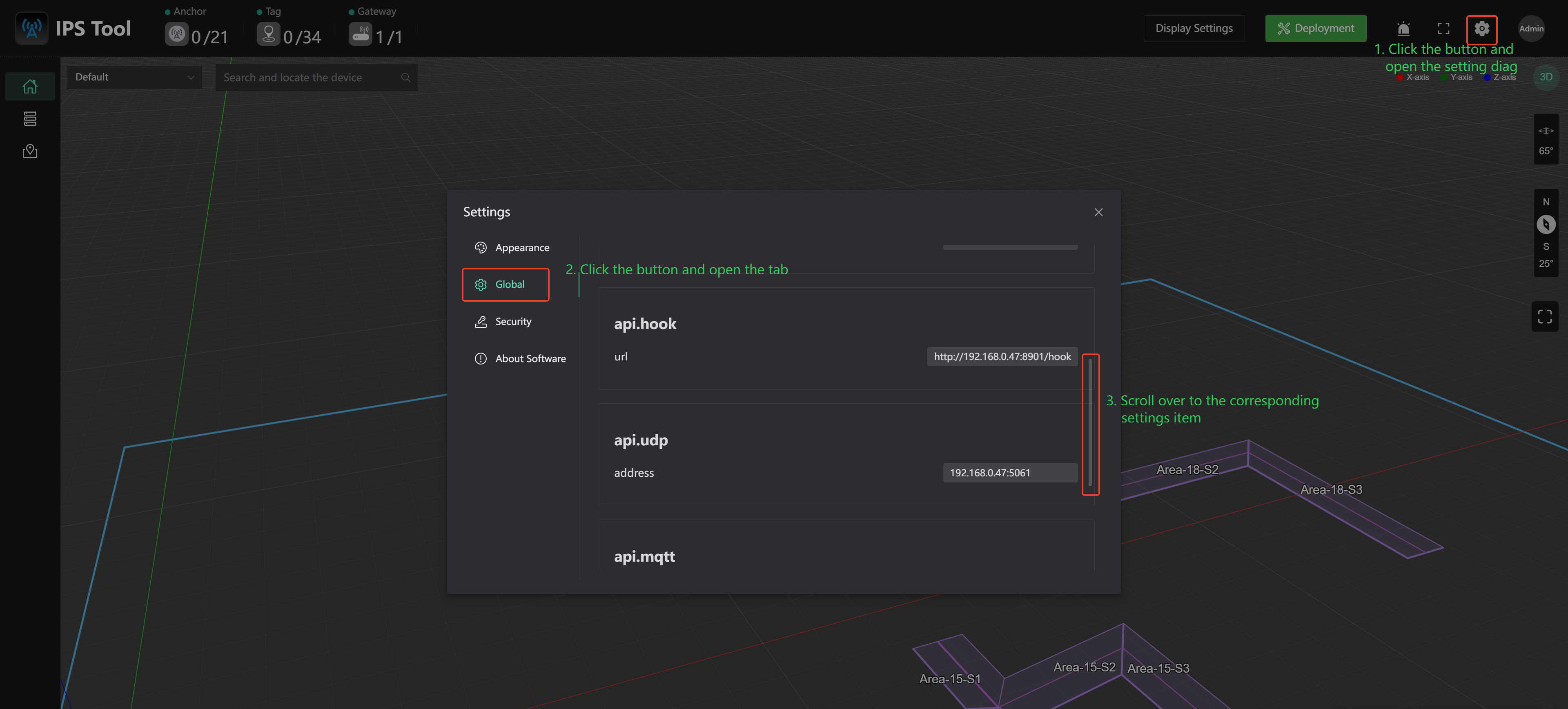
2. Push data API configuration entry
Open the IPS Tool software and follow the steps below to enter the configuration page.
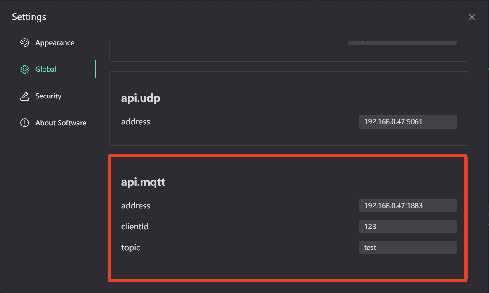
3. Push data through MQTT protocol
address: Protocol://username:password@hostname:port or Protocol://hostname:port
Unencrypted Protocol support: mqtt or tcp, ws
Encryption Protocol support: mqtts or tcps, wss
Example:mqtt://admin:test@192.168.0.15:1883
clientId: Client identification, can be empty
topic: Topic name
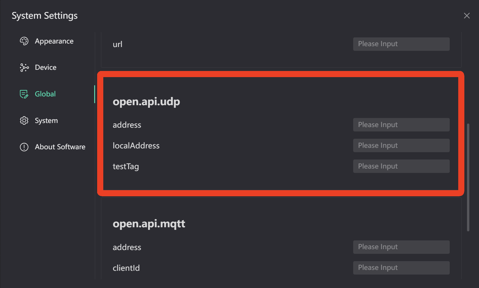
4. Push data through UDP protocol
address: {ip or domain name}:{port}
localAddress: Specify the local IP address, mainly to specify the selected network card when there are multiple network cards
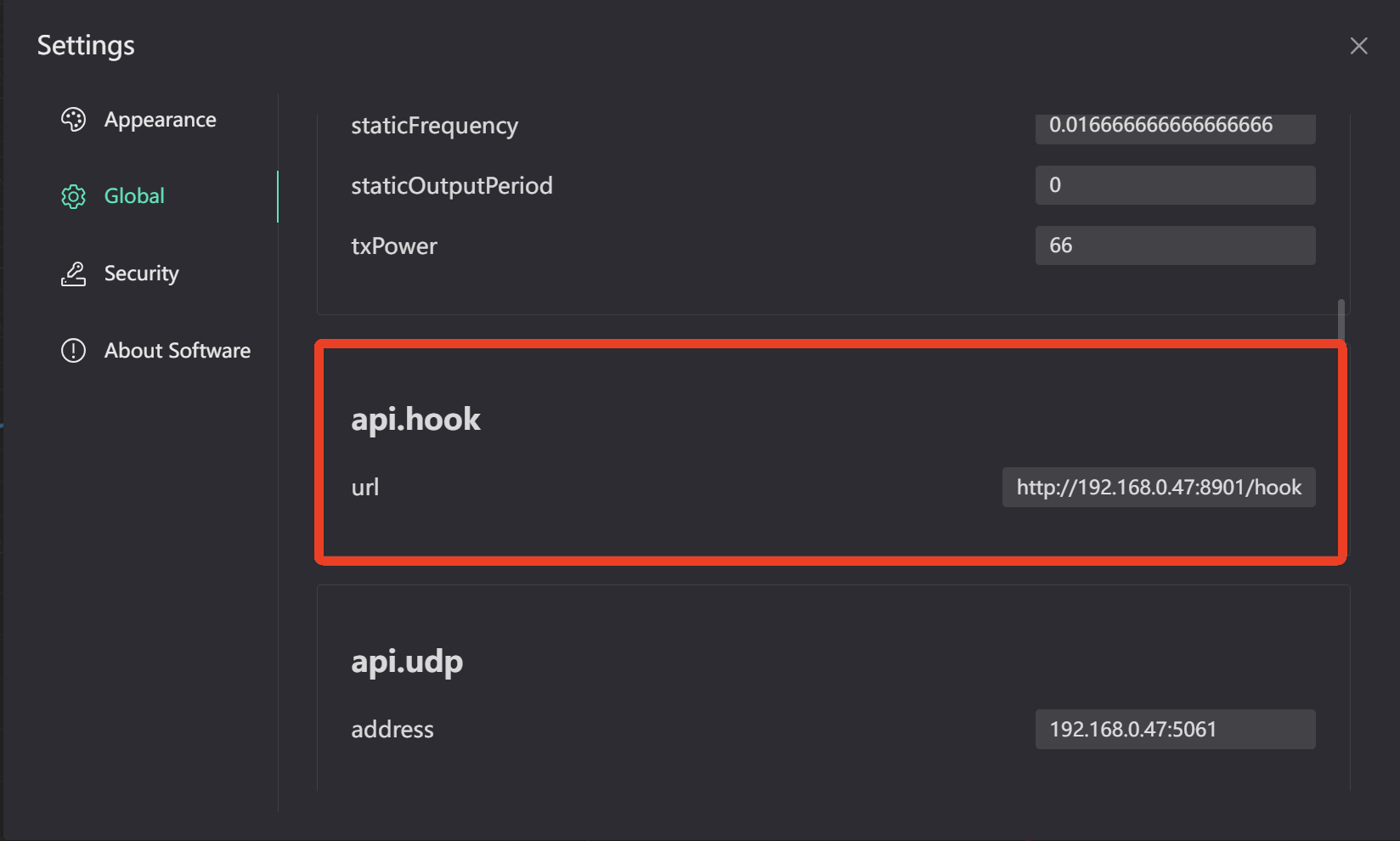
5. Push data through webhook protocol
url格式: http://{ip or domain name}:{port}/{custom uri}
http method: POST
6. Get device status through HTTP protocol
URL: GET http://localhost:8080/openapi/v1/devices?deviceType=&online=&query=&page=&pageSize=
Query parameter:
| Parameter name | Parameter type | Parameter description |
|---|---|---|
| deviceType | int | Search based on device type. Empty means querying all types of devices, 4 means querying Anchor devices, 5 means querying Tag devices. |
| online | bool | Depending on whether to search online, empty means querying all statuses, false means querying offline devices, and true means querying online devices. |
| query | string | Search based on device name prefix or device UID prefix |
| page | int | Pagination page number, the default is 1, 1 means the first page, and so on. |
| pageSize | int | The size of each page for paging, the default is 20, the maximum is 100 |
Response data:
{
    "code": 0, // 0 indicates success, non-0 indicates failure
    "message": "",
    "data": {
        "records": [
          {
            "type": 4,  // Device type, 4 represents Anchor device, 5 represents Tag device
            "online": false, // Device online status
            "onlineTime": 1727323909, // Online and offline time, online is true to indicate online time, online is false to indicate offline time
            "uid": "1b00530007503148", // Device UID
            "product": "A01", // Device product
            "coordinate": { // Device coordinates, currently only Anchor devices have
                "coords": [
                  13.302,  // x-axis
                  12.9,    // y-axis
                  2.9      // z-axis
                ]
             },
             "name": "A1" // Device name
           },
           {
             "type": 5, // Device type, 4 represents Anchor device, 5 represents Tag device
             "online": false, // Device online status
             "onlineTime": 1730860539, // Online and offline time, online is true to indicate online time, online is false to indicate offline time
             "uid": "72bc78a7911d836f", // Device UID
             "power": 50,  // Device battery percentage
             "product": "T02", // Device product
             "name": "T5" // Device name
           }
    	],
    	"total": 1 // Total number for current search criteria
    }
}
7. Send transparent data to tag through HTTP protocol
URL: PUT http://localhost:8080/openapi/v1/devices/{uid}/services/TransmitData
Query Parameter:
| Parameter name | Parameter type | Parameter description |
|---|---|---|
| uid | string | Device UID |
Body Parameter:
| Parameter name | Parameter type | Parameter description |
|---|---|---|
| data.data | string | Transparent data. |
| data.codec | string | Data encoding format, utf8 means utf8 encoding, hex means hex encoding, empty or other means base64 encoding |
{
    "data":{
        "data":"123",
        "codec":"utf8"
    }
}
Response data:
{
    "code": 0, // 0 indicates success, non-0 indicates failure
    "message": ""
}
8. Send formatted transparent data to tag through HTTP protocol
URL: PUT http://localhost:8080/openapi/v1/devices/{uid}/services/FormatTransmitData
Query Parameter:
| Parameter name | Parameter type | Parameter description |
|---|---|---|
| uid | string | Device UID |
Body Parameter:
| Parameter name | Parameter type | Parameter description |
|---|---|---|
| data.data | string | Transparent data. |
| data.codec | string | Data encoding format, utf8 means utf8 encoding, hex means hex encoding, empty or other means base64 encoding |
{
    "data":{
        "data":"123",
        "codec":"utf8"
    }
}
Response data:
{
    "code": 0, // 0 indicates success, non-0 indicates failure
    "message": ""
}
9. Send call command to tag through HTTP protocol
URL: PUT http://localhost:8080/openapi/v1/devices/{uid}/services/Call
Query Parameter:
| Parameter name | Parameter type | Parameter description |
|---|---|---|
| uid | string | Device UID |
Body Parameter:
| Parameter name | Parameter type | Parameter description |
|---|---|---|
| data.duration | int | Call duration, unit: s, maximum: 64 |
{
    "data":{
        "duration": 1
    }
}
Response data:
{
    "code": 0, // 0 indicates success, non-0 indicates failure
    "message": ""
}
10. Send a cancel call command to tag through HTTP protocol
URL: PUT http://localhost:8080/openapi/v1/devices/{uid}/services/CancelCall
Query Parameter:
| Parameter name | Parameter type | Parameter description |
|---|---|---|
| uid | string | Device UID |
Response data:
{
    "code": 0, // 0 indicates success, non-0 indicates failure
    "message": ""
}
11. Send response call command to tag through HTTP protocol
URL: PUT http://localhost:8080/openapi/v1/devices/{uid}/services/Ack
Query Parameter:
| Parameter name | Parameter type | Parameter description |
|---|---|---|
| uid | string | Device UID |
Body Parameter:
| Parameter name | Parameter type | Parameter description |
|---|---|---|
| data.reqId | string | Value is CallAck. |
{
    "data":{
        "reqId": "CallAck"
    }
}
Response data:
{
    "code": 0, // 0 indicates success, non-0 indicates failure
    "message": ""
}
12. Query electronic fences on the map through HTTP protocol
URL: GET http://localhost:8080/openapi/v1/maps/{mapId}/fences
Path Parameter:
| Parameter name | Parameter type | Parameter description |
|---|---|---|
| mapId | uint32 | Geo-fence location map ID |
Response data:
{
    "code": 0, // 0 indicates success, non-0 indicates failure
    "message": "",
    "data": {
        "records": [
            {
                "id": 11, // Electronic fence id
                "mapId": 2, // Geo-fence location map ID
                "name": "Test", // Electronic fence name
                "enable": true, // Is the electronic fence enabled
                "bounds": [
                    [
                        [
                            19.305483719334006,
                            14.511200794018805
                        ],
                        [
                            21.019341055303812,
                            14.511200794018805
                        ],
                        [
                            21.019341055303812,
                            13.554935615509748
                        ],
                        [
                            19.305483719334006,
                            13.554935615509748
                        ],
                        [
                            19.305483719334006,
                            14.511200794018805
                        ]
                    ]
                ], // Geo-fence boundaries (holes are not currently supported)
                "leaveBuffer": 0.3, // When the distance from the electronic fence boundary is greater than leaveBuffer, it is considered to have left.
                "includes": ["d910570506e6d4f7"],// The tag UID of the electronic fence that is effective. If it is empty, it means all are effective.
                "excludes": ["d48475ae51904290"],//The tag UID for which the electronic fence is not effective. If it is empty, it means all are effective.
                "userData": {} // User-defined data
            }
        ]
    }
}
13. Search electronic fences through HTTP protocol
URL: GET http://localhost:8080/openapi/v1/fences
Query Parameter:
| Parameter name | Parameter type | Parameter description |
|---|---|---|
| mapId | uint32 | Geo-fence location map ID |
| query | string | Search by geo-fence name prefix |
| page | int | The default pagination number is 1, which means the first page, and so on. |
| pageSize | int | The default page size is 20, and the maximum is 100. |
Response data:
{
    "code": 0, // 0 indicates success, non-0 indicates failure
    "message": "",
    "data": {
        "records": [
            {
                "id": 11, // Electronic fence id
                "mapId": 2, // Geo-fence location map ID
                "name": "Test", // Electronic fence name
                "enable": true, // Is the electronic fence enabled
                "bounds": [
                    [
                        [
                            19.305483719334006,
                            14.511200794018805
                        ],
                        [
                            21.019341055303812,
                            14.511200794018805
                        ],
                        [
                            21.019341055303812,
                            13.554935615509748
                        ],
                        [
                            19.305483719334006,
                            13.554935615509748
                        ],
                        [
                            19.305483719334006,
                            14.511200794018805
                        ]
                    ]
                ], // Geo-fence boundaries (holes are not currently supported)
                "leaveBuffer": 0.3, // When the distance from the electronic fence boundary is greater than leaveBuffer, it is considered to have left.
                "includes": ["d910570506e6d4f7"],// The tag UID of the electronic fence that is effective. If it is empty, it means all are effective.
                "excludes": ["d48475ae51904290"],//The tag UID for which the electronic fence is not effective. If it is empty, it means all are effective.
                "userData": {} // User-defined data
            }
        ],
        "total": 1 // The total number of current search terms
    }
}
14. Load some electronic fence through HTTP protocol
URL: GET http://localhost:8080/openapi/v1/fences/\{id\}
Path Parameter:
| Parameter name | Parameter type | Parameter description |
|---|---|---|
| id | uint32 | Electronic fence id |
Response data:
{
    "code": 0, // 0 indicates success, non-0 indicates failure
    "message": "",
    "data": {
        "mapId": 2, // Geo-fence location map ID
        "name": "Test", // Electronic fence name
        "enable": true, // Is the electronic fence enabled
        "bounds": [
            [
                [
                    19.305483719334006,
                    14.511200794018805
                ],
                [
                    21.019341055303812,
                    14.511200794018805
                ],
                [
                    21.019341055303812,
                    13.554935615509748
                ],
                [
                    19.305483719334006,
                    13.554935615509748
                ],
                [
                    19.305483719334006,
                    14.511200794018805
                ]
            ]
        ], // Geo-fence boundaries (holes are not currently supported)
        "leaveBuffer": 0.3, // When the distance from the electronic fence boundary is greater than leaveBuffer, it is considered to have left.
        "includes": ["d910570506e6d4f7"],// The tag UID of the electronic fence that is effective. If it is empty, it means all are effective.
        "excludes": ["d48475ae51904290"],//The tag UID for which the electronic fence is not effective. If it is empty, it means all are effective.
        "userData": {} // User-defined data
    }
}
15. Add electronic fence through HTTP protocol
URL: POST http://localhost:8080/openapi/v1/fences
Response data:
| Parameter name | Parameter type | Parameter description |
|---|---|---|
| name | string | Electronic fence name |
| enable | bool | Is the electronic fence enabled |
| bounds | [][][][][][][]float64 | Geo-fence boundaries (holes are not currently supported) |
| leaveBuffer | float64 | When the distance from the electronic fence boundary is greater than leaveBuffer, it is considered to have left. |
| includes | []string | The tag UID of the electronic fence that is effective. If it is empty, it means all are effective. |
| excludes | []string | The tag UID for which the electronic fence is not effective. If it is empty, it means all are effective. |
| userData | Object | User-defined data |
{
    "mapId": 2, // Geo-fence location map ID
    "name": "Test", // Electronic fence name
    "enable": true, // Is the electronic fence enabled
    "bounds": [
        [
            [
                19.305483719334006,
                14.511200794018805
            ],
            [
                21.019341055303812,
                14.511200794018805
            ],
            [
                21.019341055303812,
                13.554935615509748
            ],
            [
                19.305483719334006,
                13.554935615509748
            ],
            [
                19.305483719334006,
                14.511200794018805
            ]
        ]
    ], // Geo-fence boundaries (holes are not currently supported)
    "leaveBuffer": 0.3, // When the distance from the electronic fence boundary is greater than leaveBuffer, it is considered to have left.
    "includes": ["d910570506e6d4f7"],// The tag UID of the electronic fence that is effective. If it is empty, it means all are effective.
    "excludes": ["d48475ae51904290"],//The tag UID for which the electronic fence is not effective. If it is empty, it means all are effective.
    "userData": {} // User-defined data
}
Response data:
{
    "code": 0, // 0 indicates success, non-0 indicates failure
    "message": ""
}
16. Update electronic fence through HTTP protocol
URL: PUT http://localhost:8080/openapi/v1/fences/{id}
Response data:
| Parameter name | Parameter type | Parameter description |
|---|---|---|
| id | uint32 | Electronic fence id |
Body参数:
| Parameter name | Parameter type | Parameter description |
|---|---|---|
| name | string | Electronic fence name |
| enable | bool | Is the electronic fence enabled |
| bounds | [][][][][][][]float64 | Geo-fence boundaries (holes are not currently supported) |
| leaveBuffer | float64 | When the distance from the electronic fence boundary is greater than leaveBuffer, it is considered to have left. |
| includes | []string | The tag UID of the electronic fence that is effective. If it is empty, it means all are effective. |
| excludes | []string | The tag UID for which the electronic fence is not effective. If it is empty, it means all are effective. |
| userData | Object | User-defined data |
{
    "name": "Test", // Electronic fence name
    "enable": true, // Is the electronic fence enabled
    "bounds": [
        [
            [
                19.305483719334006,
                14.511200794018805
            ],
            [
                21.019341055303812,
                14.511200794018805
            ],
            [
                21.019341055303812,
                13.554935615509748
            ],
            [
                19.305483719334006,
                13.554935615509748
            ],
            [
                19.305483719334006,
                14.511200794018805
            ]
        ]
    ], // Geo-fence boundaries (holes are not currently supported)
    "leaveBuffer": 0.3, // When the distance from the electronic fence boundary is greater than leaveBuffer, it is considered to have left.
    "includes": ["d910570506e6d4f7"],// The tag UID of the electronic fence that is effective. If it is empty, it means all are effective.
    "excludes": ["d48475ae51904290"],//The tag UID for which the electronic fence is not effective. If it is empty, it means all are effective.
    "userData": {} // User-defined data
}
Response data:
{
    "code": 0, // 0 indicates success, non-0 indicates failure
    "message": ""
}
17. Delete electronic fence through HTTP protocol
URL: DELETE http://localhost:8080/openapi/v1/fences/{id}
Path Parameter:
| Parameter name | Parameter type | Parameter description |
|---|---|---|
| id | uint32 | Electronic fence id |
Response data:
{
    "code": 0, // 0 indicates success, non-0 indicates failure
    "message": ""
}